When Kenya Meteorological Department released Advisory No. 03/2025Nairobi on Wednesday, 23 October 2025 at 11:00 AM EAT, Kennedy Tyongo, Acting Director of the department, warned that heavy rainfall exceeding 30 mm within 24 hours would pound 39 counties from Thursday afternoon through the following Wednesday evening. The alert carries a medium‑level risk rating with a 33‑66 percent probability of occurrence, and it comes just as Kenya’s short‑rain (OND) season is poised to kick in.
Scope of the Advisory
The warning covers a swath of Kenya that stretches from the Lake Victoria Basin in the west, across the Rift Valley, into the Nairobi Metropolitan Area, and eventually to the north‑eastern arid lands. The 39 counties named include Kisumu, Homa Bay, Siaya, Migori, Busia, Kisii, Nyamira, Nandi, Kericho, Bomet, Kakamega, Vihiga, Bungoma, Narok, Baringo, Nakuru, Trans Nzoia, Uasin Gishu, Elgeyo‑Marakwet, West Pokot, Turkana, Isiolo, Samburu, Marsabit, Mandera, Wajir, Nyandarua, Laikipia, Nyeri, Kajiado, Tharaka‑Nithi, Embu, Meru, Kiambu, Murang'a, Kirinyaga, Makueni, Machakos, and Nairobi County itself.
Rainfall is already sloshing through parts of the Lake Victoria Basin and the highlands west of the Rift Valley, with forecasts showing an intensification to over 30 mm within the first 24 hours. By Thursday evening the storm front is expected to spill into the highlands east of the Rift Valley – including Nairobi – and then sweep across the south‑eastern lowlands. The final leg will reach the north‑eastern region by 30 October, signaling the onset of the OND short‑rain season across most of the country, sparing only small coastal stretches.
What Residents Need to Know
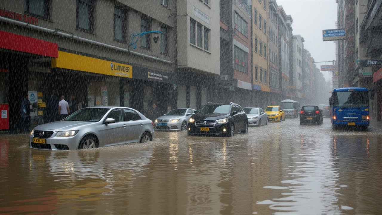
Tyongo’s advisory isn’t just about rain; it comes with a laundry list of safety tips. He urged anyone in the affected counties to avoid driving or walking through moving water, to stay clear of trees that could attract lightning, and to keep away from windows fitted with metallic grills during thunderstorms. In landslide‑prone zones – such as the highlands of Kericho and the escarpments around Nakuru – residents were told to remain on high alert and be prepared to relocate at a moment’s notice.
Gusty winds blowing at more than 25 knots will accompany the downpours, enough to peel off loose roofing tiles and uproot young trees. The department cautioned that these winds could exacerbate flooding by tearing down barriers that normally channel runoff.
Local authorities have already begun pre‑positioning sandbags in low‑lying neighborhoods of Kisumu and Nakuru, and the National Disaster Operation Centre has put emergency teams on standby for rapid deployment.
Potential Impacts and Historical Context
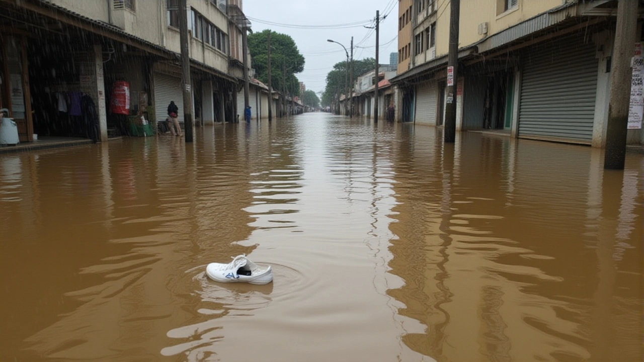
Kenya’s short‑rain season usually accounts for 30‑40 percent of the nation’s annual rainfall. In 2023, the OND period delivered 150‑200 percent of normal rainfall in western Kenya, flooding roads, destroying bridges, and damaging crops – yet it also boosted maize yields the following year. This year, drought‑stricken regions of the north‑east hope the rains will refill depleted reservoirs, while the western lake basins brace for possible overflows; water levels in Lake Victoria have been rising steadily since early October 2025.
Past medium‑level advisories in October have been mixed bags: the 2021 warning resulted in roughly 12 cm of rain over the Rift Valley, causing minor flash floods but no loss of life. Conversely, the 2022 advisory preceded a catastrophic flood in Busia that claimed 27 lives and forced over 5 000 people into temporary shelters. The current advisory’s longer duration – a full seven days instead of the usual three – raises concerns about cumulative runoff and soil saturation.
Government and Emergency Responses
The Ministry of Interior and Coordination of National Government has scheduled an emergency coordination meeting for Friday, 24 October 2025 at 9:00 AM EAT. County disaster management officers are expected to present updated contingency plans, focusing on evacuation routes, medical supply distribution, and temporary shelter allocation.
In Nairobi, the city’s flood‑mitigation unit has already issued road‑closure advisories for the 2nd Avenue and parts of the Mombasa Road, where low‑lying drainage channels are known to back up during heavy downpours. The unit’s spokesperson, James Mwangi, told reporters, “We’re deploying mobile pumps to key choke points and urging commuters to use alternative routes. Safety is our top priority.”
Meanwhile, the Kenya Red Cross Society is mobilising volunteers to conduct community awareness campaigns, distributing flyers that echo Tyongo’s safety tips and setting up first‑aid stations at strategic market centres in Kakamega and Kiambu.
Looking Ahead: The OND Season
Forecast models from the department suggest that rainfall intensity will start to taper off by Monday, 3 November 2025, although isolated thunderstorms may linger in the highlands. If the expected 30‑mm threshold is met consistently across the Rift Valley, agronomists predict a modest boost in coffee and tea yields for the 2025‑2026 harvest.
Experts from the University of Nairobi’s Department of Climate Studies warn, however, that climate variability could make this “short‑rain” window increasingly erratic. Prof. Amina Hassan noted, “While the rains bring much‑needed water, the accompanying flash‑flood risk is a stark reminder that infrastructure resilience must keep pace with climate change.”
- Advisory No. 03/2025 issued 23 Oct 2025, 11:00 AM EAT.
- Rainfall >30 mm expected within 24 hours across 39 counties.
- Wind gusts >25 knots, potential roof and tree damage.
- Medium‑level risk (33‑66 % probability).
- Emergency meeting by Ministry of Interior scheduled 24 Oct, 9:00 AM EAT.
Frequently Asked Questions
How will the heavy rain affect farmers in the Rift Valley?
The rains are likely to replenish soil moisture and boost maize and wheat planting, but flash‑floods could erode topsoil on steep slopes. Extension officers are urging farmers to adopt contour farming and safeguard seedlings with sandbags where possible.
What safety measures should drivers take during the advisory period?
Drivers should avoid low‑lying bridges and roads prone to sudden water flow, keep headlights on low‑beam to reduce glare from rain, and pull over safely if visibility drops below 50 meters. Authorities have posted detour signs on major highways in Kisumu and Nakuru.
Will the short‑rain season bring relief to drought‑hit north‑eastern Kenya?
Meteorologists expect the north‑eastern counties to receive intermittent showers from 30 October onward, which could raise reservoir levels by up to 12 percent. However, the rainfall may be uneven, so water‑storage projects remain critical.
What is the expected timeline for the rains to subside?
The department’s models show a gradual weakening of the system beginning Monday, 3 November 2025, with isolated thunderstorms likely persisting in the highlands through the first week of November.
How are emergency services preparing for potential floods?
The National Disaster Operation Centre has pre‑positioned rescue boats in Kisumu, Nakuru, and Kitale, while the Kenya Red Cross is training volunteers in swift water rescue. County health units are stocking oral rehydration salts and antimalarial drugs in anticipation of water‑borne disease risks.
Sreeramana Aithal
Seeing the warning, it’s obvious that many people still treat climate warnings like optional suggestions 😡. The heavy rains are a reminder that our collective negligence has real consequences for the vulnerable communities across Kenya. Ignoring the simple safety tips is practically an invitation for disaster, and it reflects a deeper moral failing in how we respect nature.
We should all be demanding stricter enforcement of zoning laws and better urban planning to prevent these flash floods.
Anshul Singhal
When a nation is hit with a sweeping meteorological advisory, it becomes a communal moment to reflect on resilience and solidarity. The heavy rain warning for thirty‑nine counties is not just a forecast; it is a call to action for every citizen, farmer, and local official. In the Lake Victoria Basin, the soils have been thirsty for months, and this rain could revitalize crops if managed wisely. Yet, history has taught us that sudden downpours can also trigger landslides in places like Kericho and Nakuru, endangering lives. The advisory wisely includes safety tips, emphasizing the avoidance of moving water, lightning‑prone trees, and fragile windows. Emergency services pre‑positioning sandbags is a proactive step that can mitigate flood damage in low‑lying neighborhoods. The government’s coordination meeting on Friday shows that there is political will to address the crisis, but execution will be the true test. Community volunteers from the Red Cross can amplify public awareness, ensuring that people understand the risks before they step outside. Farmers should consider contour plowing and terrace construction to reduce runoff, which will protect both soil integrity and future harvests. Urban commuters in Nairobi should utilize alternative routes, as closed avenues could otherwise become bottlenecks. The wind gusts above 25 knots could dislodge rooftop tiles, so homeowners ought to inspect their structures now. Climate scientists warn that such short‑rain windows are becoming more erratic, highlighting the need for adaptive infrastructure. While the rains may boost coffee and tea yields in the highlands, the accompanying flash‑flood risk must not be downplayed. In the end, collective preparedness, clear communication, and swift response will determine whether this heavy rain becomes a blessing or a catastrophe.
Let’s all stay informed, stay safe, and support each other through the coming week.
DEBAJIT ADHIKARY
Thank you for the comprehensive overview. Your points regarding soil conservation and infrastructure adaptation are well noted. The emphasis on community engagement aligns with best practices in disaster risk reduction. I appreciate the balanced perspective you provided.
abhay sharma
Sure we all love a good mud bath on our way to work
Abhishek Sachdeva
The sarcasm misses the gravity of the situation. Heavy rainfall exceeding 30 mm in a day can overwhelm drainage systems, especially in poorly maintained urban corridors. Historical data from the 2022 Busia floods shows that neglecting these warnings leads to loss of life and property. Authorities must enforce road closures and expedite sandbag distribution, otherwise we repeat past tragedies. Residents should treat the advisory as a mandatory directive, not a suggestion.
Janki Mistry
Rainfall >30 mm triggers hydro‑graph peaks increasing runoff coefficients; ensure hydraulic capacity of culverts meets design flow. Deploy portable pumps to maintain discharge Q≥5 m³/s in critical basins.
Akshay Vats
It’s unaccepptable that people still drive through flood waters like nothing happend 😤. The goverment should enforce stricter penalties for reckless behaviour. If we dont take responsibility now, future generations will pay the price.
Anusree Nair
Let’s come together as a community and look out for each other during these heavy rains. Your neighbor might need a helping hand to move sandbags or check on an elderly family member. Small acts of kindness can make a big difference when the waters rise.
Bhavna Joshi
Community cohesion is a vital component of disaster risk reduction, as it enhances social capital and facilitates rapid information dissemination. Integrating local knowledge with formal early‑warning systems can improve response times and reduce vulnerability. I encourage the formation of neighborhood response teams equipped with basic rescue gear.
Vakil Taufique Qureshi
The recurring flood warnings reveal a systemic failure in land‑use planning that has been ignored for decades. Without a fundamental overhaul of zoning regulations, any temporary measures are merely Band‑Aid solutions.
Jaykumar Prajapati
It’s no coincidence that the same officials who ignored the 2021 advisory are now suddenly “pre‑positioning” sandbags. Some behind‑the‑scenes players benefit from the chaos, selling rescue equipment at inflated prices while the public bears the brunt. The drama unfolds, and we must stay vigilant.
PANKAJ KUMAR
Recent satellite imagery shows that the Lake Victoria basin is already experiencing a rise of 12 cm in water level, which could exacerbate overflow in low‑lying districts. Coordination between meteorological services and local water boards is essential to manage this surge effectively.
Anshul Jha
While foreign NGOs parade their aid, true resilience comes from national pride and self‑reliance. Our own engineers should design flood barriers without relying on external consultants. Anything less is a compromise of sovereignty.
Anurag Sadhya
Great insights everyone 😊. Remember to keep your emergency kits stocked and share updates with neighbors. Together we can navigate these storms safely 🌧️.